- Folder Containing .dbf .idx .prj .shp .shx Files
- Certified Plat of Survey Signed 2-15-23
SC Code of Law: (http://www.scstatehouse.gov/code/t04c003.php)
SECTION 4-3-100. Charleston County: ....thence following the ordinary high-water line on the eastern bank of said river to a point on the ordinary high-water line of the eastern bank of the Ashley River 472 ft. west of the point where Sawpit Creek enters the Ashley River; thence from said point on a true bearing of N 22� 38' 39" E along a ditch on the eastern boundary of Archdale Hall subdivision and onward for a total distance of 248.61 chains to a concrete monument marked "CHAS/DOR"; thence on a true bearing of N 42� 15' 31" W to a point of intersection with the property line of Monroe E. and Winifred J. Hartzog; thence northeastward 800 ft. following the property line of Monroe E. and Winifred Hartzog to a point of intersection with the property line of James C. and Mary Palmer; thence southeastward following the property line of James C. and Mary Palmer for 406 ft. � thence northeastward to a point on the north side of Secondary State Highway S10-1120 (Jamison Road); thence eastward following the northern boundary of Secondary State Highway S10-1120 (Jamison Road) to its intersection with the northwestern boundary of Secondary State Highway S10-76 (Ladson Road); thence following the northwestern boundary of Secondary State Highway S10-76 (Ladson Road) to the intersection of the northwestern boundary of Secondary State Highway S10-76 (Ladson Road) and the southwestern boundary of Secondary State Highway S10-881 (Lincolnville Road); thence northwestward, a distance of 9,700 ft. � following the southwestern boundary of Secondary State Highway S10-881 (Lincolnville Road) to a point; thence southwestward 5,400 ft. � to a point; thence northwestward 550 ft. � to a point; thence southwestward 600 ft. � to a point; thence northwestward on a true bearing of N 42� 15' 31" W to the center line of Sawmill Branch, 51.1 chains southwest of the southwestern right-of-way line of the Norfolk Southern Corporation (measured in a straight line); thence from this point following the center line of Sawmill Branch to its intersection with the southeastern right-of-way line of Richardson Avenue; thence from this point southeastward along the southeastern right-of-way of Richardson Avenue to its intersection with Owens Road; thence northeastward following the eastern boundaries of Challedon and Meadowbrook subdivisions to a point on the north side of East Third Street North; thence northwestward a distance of 1,200 ft. � to a point; thence northeastward to a point on the north side of U.S. Highway 78 (5th North); thence southeastward following the northern boundary of U.S. Highway 78 (5th North) to a point; thence southwestward a distance of 325 ft. � to a point; thence southeastward a distance of 379 ft. � to a point; thence northeastward a distance of 325 ft. � to a point on the north side of U.S. Highway 78 (5th North); thence a distance of approximately 760 ft. � to a point; thence northeastward a distance of 1,500 ft. � following the property line of the real estate of John Finucan and Maggie F. Peters to a point at which the northeastern corner of Dorchester County intersects with Berkeley and Charleston counties;......
SECTION 4-3-200: Dorchester County: ......and by a straight line running thence to a point upon Saw Mill Branch one mile northeast of the South Carolina and Georgia Railroad, and thence along said branch to the old division line between Colleton and Berkeley Counties; and thence by said old division line to the point where said line intersects the division line between Charleston and Berkeley Counties; on the southeast by Charleston County, from which it is separated by the old division line between Charleston and Colleton Counties to Lowndes' Landing, on Rantowles Creek;.......
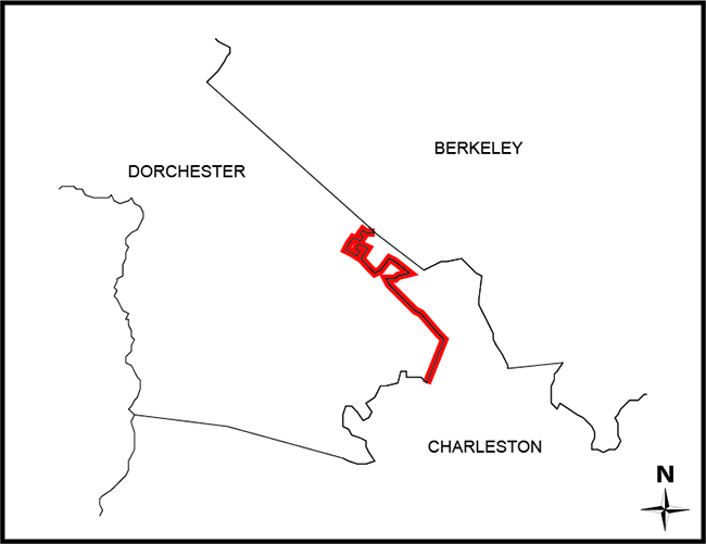
SECTION 4-3-210: Dorchester County; portion of Lincolnville area in Charleston County transferred to Dorchester County.
SECTION 4-3-220: Dorchester County; additional area of Charleston County transferred to Dorchester County.
SECTION 4-3-230: Dorchester County; additional area of Charleston County transferred to Dorchester County; designation of area. The portion of Charleston County described below is hereby annexed to and made a part of Dorchester County:
SECTION 4-3-232: Dorchester County; additional area of Charleston County transferred to Dorchester County.
SECTION 4-3-233: Dorchester County; additional area of Charleston County transferred to Dorchester County.
SECTION 4-3-236: Dorchester County; portion of Charleston County transferred to Dorchester County.
- Map of portion of Berkeley Co. containing 35.33 SQ.MI. proposed annex to Charleston Co., dated July 1920. Prepared by P.G. Gourdris, G.T. Floyd & Julius P. Gamble Jr. Filed in the South Carolina Department of Archives.
- Plat of survey to incorporate a portion of Charleston County into Dorchester County, dated 08-29-1969. Prepared by RLS No. 2080 G.E. Miley Jr., RLS No. 2322 Lloyd S. Moore and RLS No.3131 Gene Whetsell. Filed in the South Carolina Department of Archives.
- Plat of a 855.61 acre tract located in Charleston County SC being considered for annexation into Dorchester County SC, dated 08-04-1976. Prepared by RLS No.4387 W.E. Gilbert and RLS No.2946 R.K. Leake. Recorded in the South Carolina Department of Archives.
- A subdivision plat of TMS NO. 232-00-02-150 to create 30 new lots, owned by Portrait Homes Summer Wood, LLC. Prepared by RLS NO. 12839 David L. Gray, dated 11-17-2004 recorded in the Office of Register of Deeds for Berkeley County SC.
- A subdivision plat of TMS NO. 232-00-02-150 to create 30 new lots, owned by Portrait Homes Summer Wood, LLC. Prepared by RLS NO. 12839 David L. Gray, dated 11-17-2004 recorded in the Office of Register of Deeds for Berkeley County SC.
- A plat showing the adjustment of the property lines for buildings 26,27,30 and 38, owned by Portrait Homes Summer Wood, LLC. Prepared by RLS NO. 12839 David L. Gray, dated 06-21-2005 recorded in the Office of Register of Deeds for Berkeley County SC.
- A plat showing the adjustment of the property lines for buildings 26,27,30 and 38, owned by Portrait Homes Summer Wood, LLC. Prepared by RLS NO. 12839 David L. Gray, dated 06-21-2005 recorded in the Office of Register of Deeds for Berkeley County SC.
- Plat of a tract of land near Summerville, located in Charleston County SC, containing 102.29 acres, dated 12-09-1966. Prepared by RLS No.2322 Llyod J Moore Jr, RLS No.2080 Gerald E Miley Jr & RLS No.660 Samuel J. Snook. Filed in the South Carolina Department of Archives.
- A plat of 158.80 acres tract located on Dorchester Road (S.C. Hwy. No. 642). Prepared by Sigma Engineers Inc., dated 08-23-1974. Recorded in the Office of Register Mesne Conveyance for Charleston County SC.
- A plat of the Charleston- Dorchester Counties County Line. Prepared by RLS NO.2507 Harold J Lea Mond, dated 07-10-1978 recorded in the Office of Register Mesne Conveyance for Charleston County SC.
- A plat TMS 397-00-00-003 Tract “A” property of Georgia Pacific Investment Company. Prepared by RLS No. 3973 Albert Heatley Jr., dated 02-27-1985 recorded in the Office of Register Mesne Conveyance for Charleston County SC.
- A plat showing the estate of Lillian J. Hilton a 53.48-acre tract of land at the intersection of Jamison Rd & Ladson Rd. Prepared by RLS No. 5933 Andrew C. Gillette, dated 10-14-1986 recorded in the Office of Register Mesne Conveyance for Charleston County SC.
- A plat showing the re-subdivision of TMS 393-00-00-006 into tracts B, B-10, B-11, property of Griffith & Knapp Properties a Partnership. Prepared by RLS NO.3973 Albert Heatley, JR., dated 03-04-1987 recorded in the Office of Register Mesne Conveyance for Charleston County SC.
- Plat of a 109.446 acre tract on Finucan Road and US Highway 78 near, dated 06-15-1988. Prepared by RLS No.10778 Thomas V. Bessent Jr. Recorded in the Office of Register Mesne Conveyance for Charleston County SC.
- Plat showing sanitary sewer easement & pump station property about to be acquired by North Charleston Sewer District from parcels 1784, 1785 & 1795. Prepared by RLS No.3973-B Albert Heatley Jr., dated 07-25-1959 recorded in the Office of Register Mesne Conveyance for Charleston County SC.
- A plat of 207.68 Acres of the Gahagan Plantation being subdivided into (8) tracts, owned by Richard V. Jenkins JR. & Robert I. Williams. Prepared by RLS NO.11053 R. David Branton, dated 10-01-1993 recorded in the Office of Register Mesne Conveyance for Charleston County SC.
- A subdivision plat showing tract 4 of the Gahagan Plantations, property of Louis J. Dimuzio SR. Prepared by RLS NO.5933-B Andrew C. Gillette, dated 03-18-1994 recorded in the Office of Register Mesne Conveyance for Charleston County SC.
- A plat showing tract A-2-B located on the east 3rd North Street, for New Roads Partners. Prepared by RLS No. 15388 John David Bass, dated 01-21-1998 recorded in the Office of Register Mesne Conveyance for Charleston County SC.
- Plat showing Tract “B”, located on Fault Line Rd, a 4.0 acre tract of land, being subdivide into two tracts. Prepared by RLS No.15388 John D. Bass, dated 08-05-2004 recorded in the Office of Register Mesne Conveyance for Charleston County SC.
- A public acquisition plat of a 2.09-acre parcel of land being subdivided from South Carolina Retarded Children’s Rehabilitation Center. Prepared by RLS No. 15388 John David Bass, dated 09-03-2004 recorded in the Office of Register Mesne Conveyance for Charleston County SC.
- Plat showing Lot 6C being subdivided from TMS 379-00-00-021 for Tideland Industrial Park LLC. Prepared by RLS No.15388 John D. Bass, dated 04-24-2007 recorded in the Office of Register Mesne Conveyance for Charleston County SC.
- A plat showing the subdivision of TMS 379-00-00-003 into tract A and TMS 379-00-00-003 residual, owned by Highway 78 Associates. Prepared by RLS NO.16120 Richard D. Lacey, dated 12-26-2000 recorded in the Office of Register Mesne Conveyance for Charleston County SC.
- A plat showing tract No1 containing 1.823 Acres and Tract No2 containing 35.010 acres, owned by Ridgefield Properties, A Tennessee General Partnership. Prepared by RLS NO.6536 Clarence Steven Matthews, dated 04-23-2005 recorded in the Office of Register Mesne Conveyance for Charleston County SC.
- A plat showing the abandonment of the property lines between 4 parcels to form an 820.405-acre tract and the subsequent subdivision of the 820.405 acre tract into 8 new tracts, property of Spring Grove Associates. Prepared by RLS NO.16120 Richard D. Lacey, dated 11-02-2005 recorded in the Office of Register Mesne Conveyance for Charleston County SC.
- Final subdivision plat showing Summerpark, phase 3A 21.801 acres, property of Centex Homes, dated 02-01-2006. Prepared by RLS No.20854 Richard A. Aldridge. Recorded in the Office of Register Mesne Conveyance for Charleston County SC.
- A plat showing the subdivision of TMS 379-00-00-075 to create 18 new lots, owned by Portrait Homes Summer Wood, LLC. Prepared by RLS NO.22742 Johnathan F. Burns, dated 08-15-2005 recorded in the Office of Register Mesne Conveyance for Charleston County SC
- A plat showing the subdivision of TMS 379-00-00-075 to create 18 new lots, owned by Portrait Homes Summer Wood, LLC. Prepared by RLS NO.22742 Johnathan F. Burns, dated 08-15-2005 recorded in the Office of Register Mesne Conveyance for Charleston County SC
- Final plat showing the subdivision of TMS 379-00-00-075 containing 7.59 acres to create 18 new lots, dated 08-15-2005. Prepared by RLS No.22742 Johnathan F. Burns. Recorded in the Office of Register Mesne Conveyance for Charleston County SC.
- A plat showing a tract of land situate in Dorchester and Charleston Counties, surveyed at the request of Mrs. Bettina V Gahagan. Prepared by A.L. Gleu, Reg.C.E., dated July 1946 recorded in the Office of Register Mesne Conveyance for Charleston County SC.
- Final survey for lots 68-99 Phase 2 and lots 43-67 Phase 3 The Pines at Gahagan Subdivision owned by The Pines at Gahagan LLC, dated 12-06-2012. Prepared by RLS No.14191 Paul C. Lawson Jr. Recorded in the Office of Register Mesne Conveyance for Charleston County SC.
- A plat showing the abolishment of tract 1 and the subdivision of the other lands belonging to Lillian I Hilton. Prepared by RLS No. 5293 David Charles Cresswell, dated 12-17-1980 recorded in the Office of Register Mesne Conveyance for Charleston County SC.
- A map of the Town of Lincolnville, compiled at the request of the Mayor and Town Council. Dated July 1988, recorded in the Office of Register Mesne Conveyance for Charleston County SC.
- A plat of a portion of a Tract of land known as “Brailsford Plantation” owned by Miss Sue L. Miles. Prepared by RLS No. 2006 Thomas W. Bailey, dated March 1964. Recorded in the Office of Register of Deeds for Dorchester County SC.
- A plat showing a boundary survey property of Mose C. Jones & Leroy W. Hilton. Prepared by RLS No. 2960 C. Roger Jennings, dated November 1980. Recorded in the Office of Register of Deeds for Dorchester County SC.
- Plat boundary of 100 acre tract property of Finucan-Peters Development Inc. Prepared by RLS No.4590 Harold Joe Willson, dated 05-08-1984. Recorded in the Office of Register of Deeds for Dorchester County SC.
- A plat showing Moultrie Place (A), The Colony (B), and Governor’s Estate (C) subdivisions. Prepared by RLS No. 5933 Andrew C Gillette, dated 05-30-1986. Recorded in the Office of Register of Deeds for Dorchester County SC.
- Plat showing a 17.165 acre tract of land property of Richard V. Jenkins and Robert I. Williams. Prepared by RLS No. 5933 Andrew C. Gillette, dated 11-14-1986. Recorded in the Office of Register of Deeds for Dorchester County SC.
- A plat of lots 17-A thru 67-A and 81-A thru 99-A block F of Pepperidge Subdivision Phase II. Prepared by RLS No.7625 Douglas M. Tompkins. Dated 03-23-1987. Recorded in the Office of Register of Deeds for Dorchester County SC.
- A plat showing Sawmill Trace Subdivision property of Gahgan Group. Prepared by RLS No. 5933 Andrew C Gillette, dated 09-19-1986. Recorded in the Office of Register of Deeds for Dorchester County SC.
- A plat showing 3 parcels “A”, “B” & “C”, Parcel “A” property of the Gahagan Group, Parcel “B” property of Garbon Group and Parcel “C” property of Twin Oaks Corporation. Prepared by RLS No. 5933-B Andrew C Gillette, dated 09-07-1989. Recorded in the Office of Register of Deeds for Dorchester County SC.
- Plat of a 12.45 acre tract of land located at South pointe, surveyed for Finucan Peters Development INC. Prepared by Associated Surveyors and Engineers, dated 06-21-1993. Recorded in the Office of Register of Deeds for Dorchester County SC.
- Boundary survey showing dedication of new right-of-way to SCDOT from TMS146-14-00-007 and acquisition of a portion of TMS154-00-00-059. Prepared by RLS No.16487 O.F. Hunter Jr, dated 05-28-2004. Recorded in the Office of Register of Deeds for Dorchester County SC.
- Subdivision plat showing Summer Park, Phase I (38.066 ac) property of BMG III LLC- JTG III LLC. Prepared by RLS No.20854 Richard A. Aldridge, dated 01-09-2005. Recorded in the Office of Register of Deeds for Dorchester County SC.
- A plat showing the subdivision of Tract 1 TMS 154-00-00-005 to for Tracts 1,2, & 3 property of Carmela T Haklisch. Prepared by RLS No. 16492 Joseph O. Eelman. Dated 10-10-2005. Recorded in the Office of Register of Deeds for Dorchester County SC.
- Plat showing parcel A, 1.93 acres, property of Charles A. & Laurie A. Hagberg. Prepared by RLS No.22745 Francis M. Harter III, dated 11-29-2005. Recorded in the Office of Register of Deeds for Dorchester County SC.
- Final subdivision plat prepared of The Lakes of Summerville- Phase I. Prepared by RLS No. 3724 Larry W. Smith. Dated 11-19-2003. Recorded in the Office of Register of Deeds for Dorchester County SC.
- Plat showing the narrowing of an existing 60’ right-of-way along with the abandonment of a portion of the right-a-way lines along Breckinridge Rd. Prepared by RLS No.20854 Richard A Aldridge. Dated 08-10-2006. Recorded in the Office of Register of Deeds for Dorchester County SC.
- Final subdivision plat of Ashley Phosphate Office Park, owned by Seventy Five Associates LLC. Prepared by RLS No.17228 James T. Reid. Dated 02-10-2009. Recorded in the Office of Register of Deeds for Dorchester County SC.
- Plat showing Tract “A-2” TMS 172-00-00-065 and Tract “A-2” (B) TMS 172-00-00-117 property of Harris Street, LLC. Prepared by RLS No.16492 Joseph O. Eelman. Dated 11-14-2011. Recorded in the Office of Register of Deeds for Dorchester County SC.
- Final plat showing Indigo Palms, Phase IV within the existing subdivision of Windsor Hill for the property of Indigo Palms IV, LLC. Prepared by RLS No.16492 Joseph O. Eelman, dated 09-23-2012. Recorded in the Office of Register of Deeds for Dorchester County SC.
- A plat showing the location of the Charleston/Dorchester County lines across Tracts 5,10,11 & 12. Prepared by RLS No.16120 Richard D Lacey. Dated 06-16-2006. Recorded in the Office of Register of Deeds for Dorchester County SC.
- A plat of the abandonment of property line between TMS# 393-00-00-061, TMS# 393-00-00-071 & TMS# 393-00-00-089 to create new Tract A. Prepared by RLS No.10292 F. Elliotte Quinn. Dated 02-01-2007. Recorded in the Office of Register of Deeds for Dorchester County SC.
Disclaimer
The Revenue and Fiscal Affairs Office is providing access to these materials for educational and research purposes and is not aware of any U.S. copyright protection (see Title 17 of the United States Code) or any other restrictions in the provided materials.
Note that the written permission of the copyright owners and/or other rights holders (such as publicity and/or privacy rights) is required for distribution, reproduction, or other use of protected items beyond that allowed by fair use or other statutory exemptions. Responsibility for making an independent legal assessment of an item and securing any necessary permissions ultimately rests with persons desiring to use the item.