

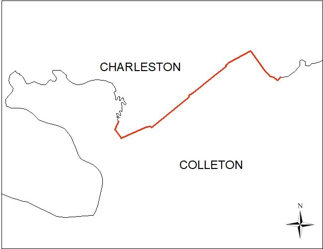
S.C. Code of Law
SC Code of Law: (http://www.scstatehouse.gov/code/t04c003.php)
SECTION 4-3-40. Charleston County.
SC Code of Law has not been updated to show this annexation.
SECTION 4-3-150 and 4-3-160. Colleton County.
SC Code of Law has not been updated to show this annexation.
Re-Establishment Survey Files
-
Certified Plat of Survey recorded at: Charleston County Plat Book L21, pages 0286 through 0291 & Colleton County Plat Book PL 958, pages 89 through 94
-
PowerPoint Presentation
-
Folder Containing .dbf .idx .prj .shp .shx Files
-
Draft of Survey
Historical and Reference Documents
-
Map Showing Area to be Annexed to Colleton County, prepared by M. Kenyon Millard, dated October 5, 1983.
-
A Compiled Plat of 2,990 Acres by Edisto Surveyors, Inc., dated August 21, 1985.
-
Bill H*2334 signed by the Governor on March 17, 1987, effective date March 17, 1987.
-
Boundary Survey of Edisto State Park, by Whitworth & Associates, Inc., dated August 29, 1990.
-
Plat of 79.34 Acres, Property of Fishing Creek Co. by H. Exo Hilton, dated January of 1973.
-
Plat of Property Conveyed to Charles W. Lucas, by Robert L. Frank, dated June 25, 1973.
-
Plat of a Resubdivision of Tracts A, B, C, & F of “The Neck” by Sigma Engineers, Inc., dated January 22, 1982.
-
Plat of Two Parcels Owned by Robert L. Frank & Stephen Schachte by Robert L. Frank, dated June 7, 1988.
-
Plat of 6.62 Acres to be Conveyed to Ted E. & Catherine R. Fontaine by David W. Spell, dated October 18, 1990.
-
) Plat Resubdivision Plat of Tract ‘G-1’ & Tract ‘G-2’ owned by Luther M. Lee & Hugh E. Jones by David W. Spell, dated September 16, 1991
-
Plat of Survey of Two Parcels of Land Owned by the Heirs of James Swinton by Robert L. Frank, dated January 25, 1993.
-
Subdivision Plat of Property Owned by A.D. McTeer by David W. Spell, dated July 13, 1993.
-
Subdivision Plat of Property about to be Conveyed to J.D. Owings, by David W. Spell, dated April 24, 1995.
-
Plat Prepared for United Methodist Church of Edisto Island, by Polson Surveying Co., dated June 1, 1994, revised December 28, 1996.
-
Boundary Survey of Property of Rosabel M. Logan by David W. Spell, dated April 13, 2000.
-
Subdivision Plat of Property owned by Margaret Reed Kenneth, by David W. Spell, dated April 12, 2000.
-
Subdivision Plat of Property owned by Sarah M. Bolton by David W. Spell, dated June 27, 2001, revised August 10, 2001
-
Boundary Survey of Property owned by Louis Gaillard by David W. Spell, dated June 19, 2001.
-
A Boundary Survey and Subdivision of the Lands of Lamont Jones by Robert L. Frank, dated October 29, 2003, revised January 4, 2004.
-
Closing Survey of the Lands of Carvin Johnson by Robert L. Frank, dated July 18, 2006, revised August 2, 2006.
-
Subdivision Plat Showing the Subdivision of Property Owned by Samuel Poinsett by George A.Z. Johnson, Jr. Inc., dated January 26, 2006, revised October 4, 2006.
-
Plat Showing a Boundary Survey of ‘Tract B’, Property owned by Charlene Gladden by Kennerly Surveying, Inc., dated November 13, 2006
-
A Resubdivision of Lots 1, 2, & 3 Located on Fishing Creek Road, by Robert L. Frank, dated October 17, 1997, revised March 24, 2000
-
A Boundary Survey and Subdivision of the Lands of Elouise Mungin by Robert L. Frank, Dated January 16, 2001, revised January 31, 2001.
-
Plat Showing the Lands of Edisloe Farms, LLC by G. Robert George and Associates, Inc., dated June 8, 2005.
-
Plat Showing Property Owned by Thomas W. and Karen M. Yeargin by George A.Z. Johnson, Jr., Inc., dated July 25, 2005.
-
Plat Showing a Private Ingress/Egress Access Easement Across the Lands of Edisloe Farms, LLC by G. Robert George and Associates, Inc., dated December 14, 2006, revised January 16, 2007.
-
A Boundary Survey and Subdivision of Seaside Oaks by Robert L. Frank, Dated April 5, 2006, Revised June 30, 2008.
-
Map of Lands of Edisto Beach, Inc and F.H. Murray, Traced by H.M. Jennings dated January 1, 1934. (From Compilation by R.F. McLellan, dated May 11, 1926)
-
Map of Edisto Beach; Lots for Sale by Edisto Beach, Inc., by Joseph Palmer, dated May 14, 1927, revised April 8, 1935.
-
A Resurvey of Property Owned by Crooked Creek Farm of Edisto, LLC by Kennerly Surveying, Inc. dated October 27, 2009.
-
Plat of Property Owned by Heirs of Rosa Hall, etal by W. Lucas Gaillard, dated January 30, 1979.
-
A Subdivision of the Estate of John Perry by Robert L. Frank, dated December 8, 1974.
-
Plat of Two Tracts of Land owned by Henry Eubank by Sigma Engineers, Inc., dated November 27, 1973.
-
A Plat of Parcels B, C and D Being a Portion of Seaside Plantation by Southeastern Surveying, Inc., dated November 14, 1995.
-
Boundary Survey for John M. Lybrand by Britt Land Surveying, dated December 7, 1998.
-
Final Subdivision Plat of Phase III – Edisto Oaks; Lot 6, 7 & 8 by G. Robert George and Associates, Inc., dated November 19, 2013.
-
Plat Showing Property Owned by Edisto Plantation, LLC Being Conveyed to New Edisto, LLC by G. Robert George and Associates, Inc., dated August 14, 2018.
-
Final Subdivision Plat of Phase V – Edisto Oaks by G. Robert George and Associates, Inc., dated January 14, 2019.
-
A Compiled Plat of 2,990 Acres by Edisto Surveyors, Inc., dated August 21, 1985, revised September 10, 1985.
-
Edisto Beach Master Plan, United States Department of Interior, National Park Service Cooperating with South Carolina Commission of Forestry.
-
Edisto Beach Master Plan, United States Department of Interior, National Park Service Cooperating with South Carolina Commission of Forestry.
-
Plan and Profile of Proposed State Highway; Charleston County; File No. 10.123A; Proj. C-123A; Road S-2352; dated May of 1984
Monuments
Note: See Plat for Geographic Coordinates of Monuments
-
1” Pipe (Found)
-
5/8” Rebar (Found)
-
1” Rebar w/Cap (Set)
-
1” Pipe (Found)
-
Concrete Monument (State Park) (Found)
-
2” Pipe (Found)
-
2” Pipe (Found)
-
1-1/4” Pipe (Found)
-
1” Rebar w/Cap (Set)
-
5/8” Rebar (Found)
-
5/8” Rebar (Found)
-
5/8” Rebar (Found)
-
1-1/2” Pipe (Found)
-
5/8” Rebar (Found)
-
5/8” Rebar (Found)
-
5/8” Rebar (Found)
-
1/2” Rebar (Found)
-
1/2” Rebar (Found)
-
1” Rebar w/Cap (Set)
-
1” Rebar w/Cap (Set)
-
1-1/2” Pipe (Found)
-
1-1/4” Pipe (Found)
-
1-1/4” Pipe (Found)
-
1-1/4” Pipe (Found)
-
1-1/4” Pipe (Found)
-
1-1/4” Pipe (Found)
-
1-1/4” Pipe (Found)
-
1” Rebar w/Cap (Set)
-
1/2” Rebar (Found)
-
Concrete Monument (Found)
-
Concrete Monument (Found)
-
1” Rebar w/Cap ((Set))
-
Concrete Monument (State Park)
-
5/8” Rebar (Found)
-
1/2” Rebar (Found)
-
3/4” Rebar (Found)
-
1” Pipe (Found)
-
2” Pipe Capped (State Park) (Found)
-
2” Pipe Capped (State Park) (Found)
-
5/8” Rebar (Found)
-
1” Pipe (Found)
-
1” Pipe (Found)
-
1” Pipe (Found)
-
1-1/2” Pipe (Found)
-
5/8” Rebar (Found)
-
1-1/2” Pipe (Found)
-
1-1/2” Pipe (Found)
-
5/8” Rebar (Found)
-
3/4” Pipe (Found)
-
3/4” Pipe (Found)
-
1-1/2” Pipe (Found)
-
1-1/2” Pipe (Found)
-
5/8” Rebar (Found)
-
5/8” Rebar (Found)
-
Concrete Monument (State Park) (Found)
-
1-1/4” Pipe (Found)
-
1-1/4” Pipe (Found)
-
Calculated Point in 36” Oak (Found)